
Anyone exploring the oceans needs state-of-the-art technology. Without assistance, humans cannot breathe underwater or see anything below 100–200 metres, depending on the light conditions. Furthermore, their organs cannot withstand the pressure at depth. It is therefore hardly surprising that the depths of the oceans remain largely unexplored.
However, technological advances have increased the possibilities for discovering the secrets of the oceans. Research submarines, underwater robots, autonomous underwater vehicles and fixed measuring stations on the sea floor and at the surface can be used to take pictures and videos, collect samples and measure data such as the salinity, temperature and pH value of the water. In most cases, it is not necessary for humans to be present below the surface of the water.
However, the technology must also meet high standards. Firstly, the equipment must be robust enough to withstand environmental conditions at sea, including wind, waves, currents, cold temperatures, high pressure and salinity. This is particularly important when the equipment is used for extended periods. Secondly, it must be precise enough to reliably perform its tasks. Such research equipment cannot be purchased with a single click online. Instead, specialised engineers and technicians develop and build customised solutions in marine institute workshops that meet researchers' requirements as well as the adverse environmental conditions in or around the ocean. However, the devices must also be compact and lightweight, as they have to be transported on ships where space is limited. At the same time, they must be easy to maintain or repair on board in case of problems.
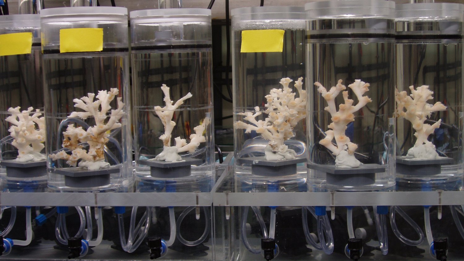
Yet, it doesn't always have to be high-tech. Sometimes, a landing net and a bucket are sufficient. In marine research, the location of sample collection is very important. Coastal waters and the ocean surface present completely different possibilities and challenges to the deep sea. The ocean can roughly be divided into three areas: the light-flooded area at the surface and near the coast; the water column (the pelagic zone); and the seabed (the benthic zone). Different equipment is used in the different areas of the sea.
How is marine research conducted on land?
However, marine research does not (only) take place on site. Although initial samples are analysed and data evaluated on research vessels, the actual work takes place on land, in laboratories. These laboratories are equipped with completely different research instruments, such as high-tech microscopes, mass spectrometers and gas chromatographs, which provide insights into the structure and processes of cells or can separate and analyse mixtures of substances. Meanwhile, the samples from the sea must be stored and prepared for experiments. There are various methods for doing this, which in turn require specialised equipment.
Land-based technology is also expensive and complex, which is why not all research institutes have all the necessary equipment on site. In particular, analytical laboratory equipment is usually found in larger research institutes, universities, or specialised laboratories. However, through close cooperation between institutions, scientists from elsewhere can book time on the equipment.

The remotely operated underwater vehicle (ROV) MARUM-QUEST 5000 is a state-of-the-art deep-sea research robot belonging to MARUM in Bremen. It has been in use since 2025. Equipped with a powerful hydraulic drive, versatile gripper arms and a modular tool carrier, the ROV can collect a variety of samples, install instruments on the seafloor and perform complex tasks at depth. Designed for operations at depths of up to 5,000 metres, MARUM-QUEST 5000 can transport up to 300 kilograms of scientific equipment.

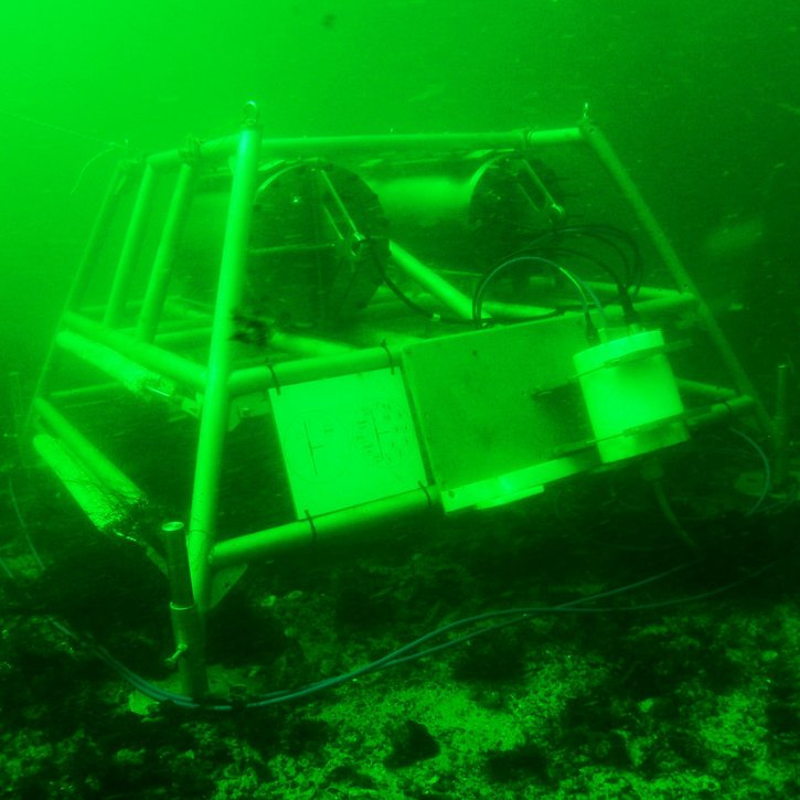
The MANSIO-VIATOR system was developed at GEOMAR to expand the range of applications for autonomous deep-sea crawlers. It does not require a fixed cable connection for power supply or data transmission. Once on the seafloor, the VIATOR can measure physical parameters such as temperature, pressure and salinity, as well as biogeochemical factors such as oxygen, carbon dioxide and pH. It can also make visual observations via cameras. The picture shows the system being tested in a swimming pool.

AUV stands for 'autonomous underwater vehicle. The AUV ABYSS is designed for use in deep-sea research. The term 'abyss' refers to the area between 2,000 and 6,000 metres below sea level, hence the name. It can map the seabed and collect physical parameters from the water column using various echo sounders and sensors. The device is powered by lithium batteries, enabling it to dive and take measurements for up to 22 hours.
The Alfred Wegener Institute (AWI) operates two underwater nodes, one off Heligoland and one off Spitsbergen. These nodes function like 'data sockets' on the seabed, to which up to ten measuring units can be connected. This enables the monitoring of water temperature, algae concentration and the seabed in real time throughout the year. The systems are remotely controlled and have a fibre-optic connection to the mainland. The nodes are part of the Coastal Observing System for the Northern and Arctic Seas (COSYNA) project, which monitors the environmental status of the North Sea and Arctic coastal waters.
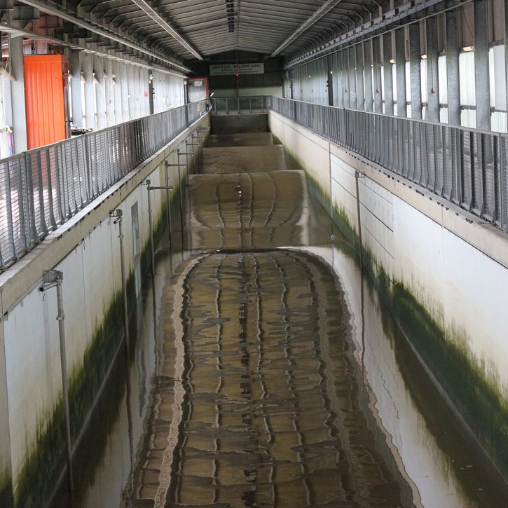
The large wave flume (GWK+) at the Coastal Research Centre is a globally unique testing facility for offshore and coastal engineering. It features a powerful wave machine, a flow facility, and a deep section for investigating foundation structures. A wide range of measurement technology is also available to record the complex processes involved in the interaction between waves, currents and structures. Wave gauges and laser scanners, for example, are used to determine the water surface level, while force transducers and acceleration sensors record the response of structures to wave loads.

The smaller the object being examined, the larger the device: the abbreviation NanoSIMS stands for Nanoscale Secondary Ion Mass Spectrometer and offers impressive spatial resolution. It can be used to observe objects around 50 nanometres in size. The emphasis is on the structures and processes inside cells, for instance in marine microbes.
Data portals as storage and resources
The collected data is transmitted to data portals, where it is stored. Scientists can then search and evaluate the data, looking for relevant information to their own research questions. Currently, however, there are numerous portals operated by different institutes that are not networked with each other. Consequently, the wealth of data collected daily is not being utilised to its full potential.
Marine research institutions affiliated with the German Marine Research Alliance (DAM) have therefore launched a data management and digitisation initiative to improve open and uniform access to decentralised data sets from German marine research. This requires adapting structures and processes, as well as applying standards for data preparation. This is already being achieved through the so-called FAIR principles: Findable, Accessible, Interoperable, Reusable. In accordance with these principles, many data sets are now generally accessible via the Marine Research Portal.
The ultimate goal is to ensure long-term, sustainable access to research data for science and society.
Direct links to marine research institute equipment
- AWI - Alfred Wegener Institute - Helmholtz Centre for polar and marine research
- BGR - Federal Institute for Geosciences and Natural Resources
- BSH - Federal Maritime and Hydrographic Agency
- FZK - Coastal Research Center of Leibniz University Hannover and Technische Universität Braunschweig
- GEOMAR - Helmholtz Centre for Ocean Research Kiel
- HEREON - Helmholtz Centre Hereon
- ICBM - Institute for Chemistry and Biology of the Marine Environment, University Oldenburg
- IOW - Leibniz Institute for Baltic Sea Research Warnemünde
- KMS - Kiel Marine Science, University Kiel
- MARUM - Center for Marine Environment Sciences at the University of Bremen
- MPI-MM - Max Planck Institute for Marine Microbiology
- MPI-M - Max Planck Institute for Meteorology
- SAM - Senckenberg am Meer, Senckenberg Society for Nature Research
- THÜNEN - Institute for Fisheries Ecology
- THÜNEN - Institute for Sea Fisheries
- ZMT - Leibniz Center for Tropical Marine Research


